A mid-1800s description of landslide topography meets 21st century lidar at Split Mountain, Haywood County, North Carolina
by Philip S. Prince
Earlier this week, I came across a recent article from Kathy N. Ross of The Mountaineer newspaper (Waynesville, NC) describing the “mystery” of Split Mountain, a spur ridge rising above the Fines Creek Community in Haywood County, North Carolina. The article is linked here, and is worth a read in conjunction with this post!
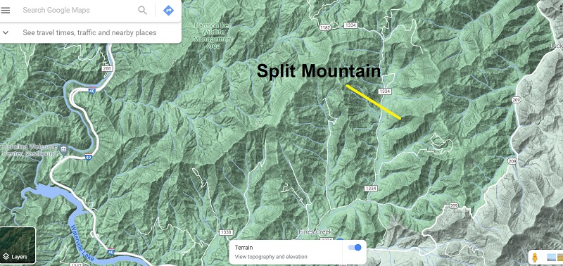
The “mystery” specifically refers to episodes of falling rock, formation of lumpy “hillocks” on previously smooth slopes, split and tilted trees, and cracked ground that gave the mountain its name in the mid-19th century. Statesman/geologist/famous North Carolinian Thomas L. Clingman visited Split Mountain three times between 1848 and 1867, describing impressive sights that significantly altered the appearance of the mountainside and conjured up suggestions of an “upheaval” event. Interestingly, none of the features Clingman described are readily apparent today, allowing the mystery to persist.
As a geologist working with landslides in western North Carolina, I found Clingman’s accounts to be clear but unintentional descriptions of a large translational landslide on a forested slope. Given the apparent size of the feature and the extremely high resolution lidar imagery I have access to, I thought it might be possible to see the feature(s) Clingman described and give them a bit more context.
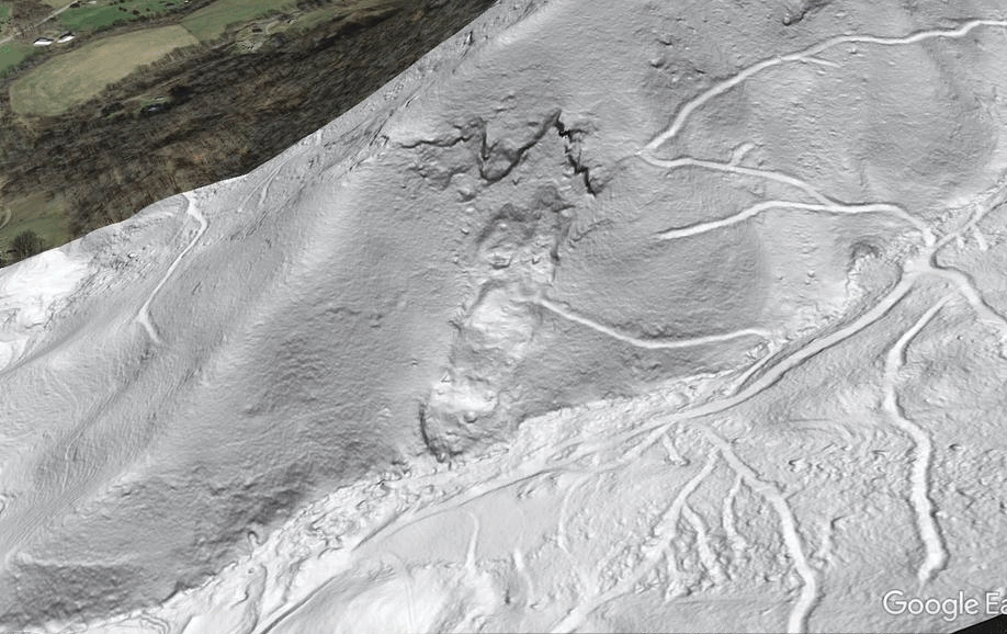
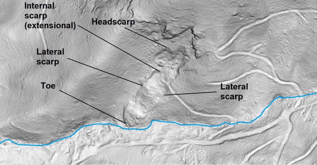
Sure enough, the south side of Split Mountain is home to a significant landslide that could indeed host many of the details that caught Clingman’s eye during his visits. The GIF below shows a slope-shade image of the feature along with aerial photography of the site. The slide is entirely re-forested, and no details of the slide-related landforms would be visible from the valley below. In fact, without the lidar dataset, this slide would go likely completely unnoticed today unless a specifically trained geologist looking for landslide topography happened to hike directly across it in just the right place!
Clingman’s observations are readily understandable in the context of landslides, and I have tried to connect them with details of the slide that are visible in lidar imagery and comparable features on a modern slide in the region. In addition to Kathy Ross’ article, a 2008 blog post (author unknown) offers a few more of Clingman’s words that contribute nicely to visualization of the Split Mountain slide. While I cannot, of course, be absolutely sure that what I am looking at is what Clingman visited, I think the chances are pretty good. The only notable disagreement between Clingman’s description and the lidar-visible slide is its size (see below), but I suppose one might expect a bit of exaggeration or at least inaccurate estimation on a forested slope.
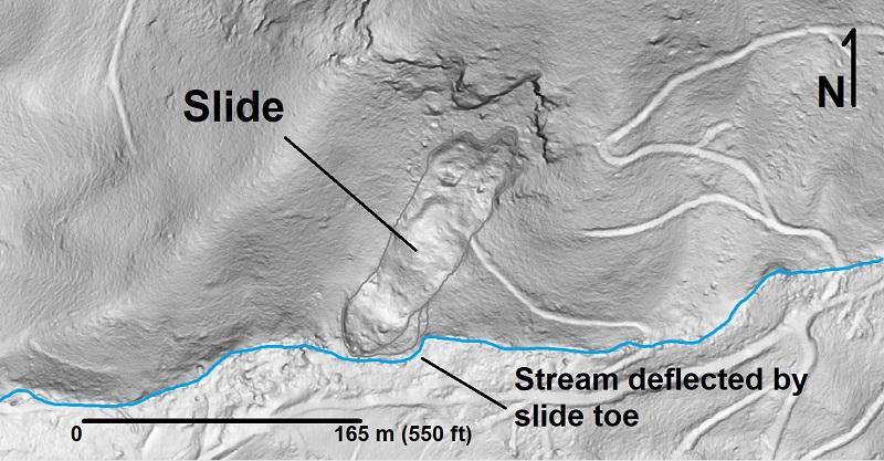
First and foremost, the slide is located on the south side of the ridge, where Clingman said the most striking “evidence of violence” could be seen. The slide is oriented close enough to the north-south trend Clingman described, and, most significantly, it has deflected the stream at the base of the hillside.
The slide is quite elongated and mostly translational in its movement, which would have produced long, crisp lateral scarps early in its development.
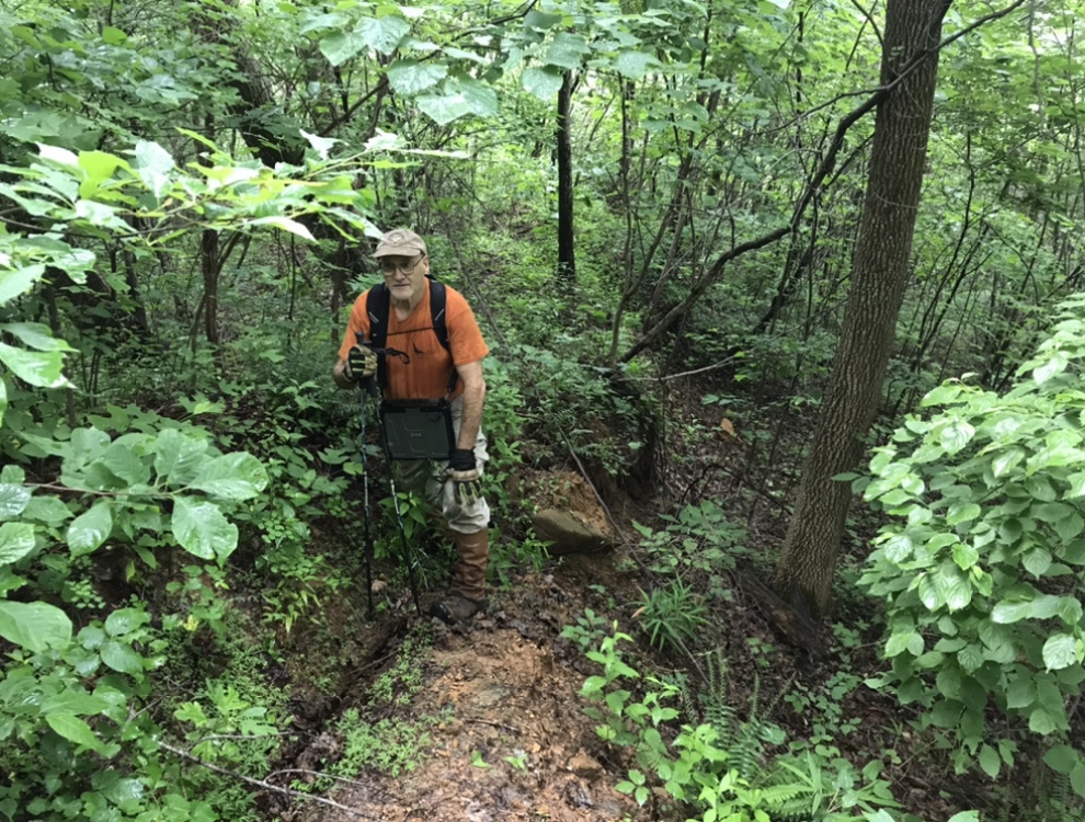
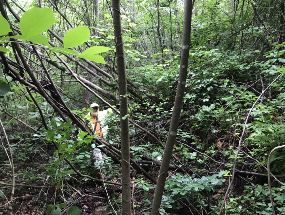
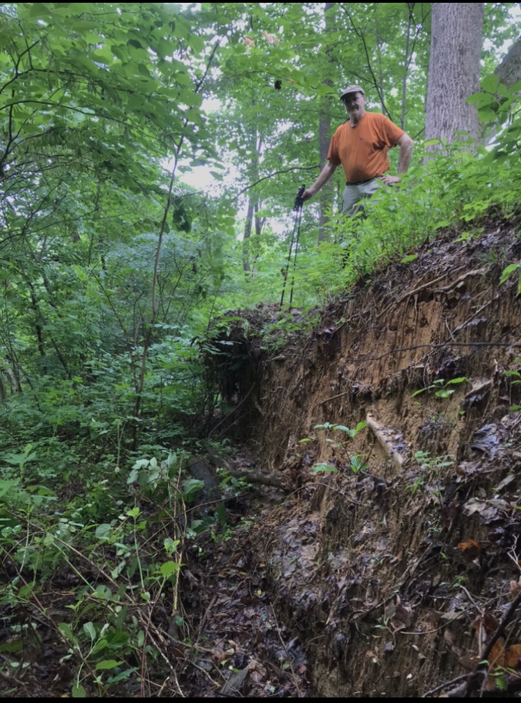
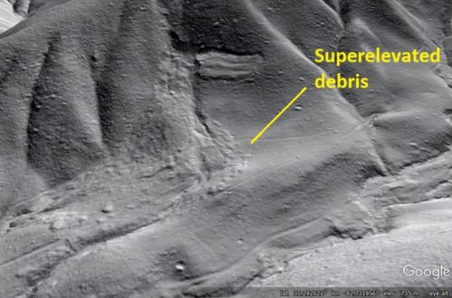
A lateral scarp in its early stages of development could be the “crack not an inch wide” that “could be traced for a hundred yards.” The photograph below shows an example of this type of lateral scarp-associated crack in Rutherford County, North Carolina, with Appalachian Landslide Consultants geologist Ken Gillon standing across it.
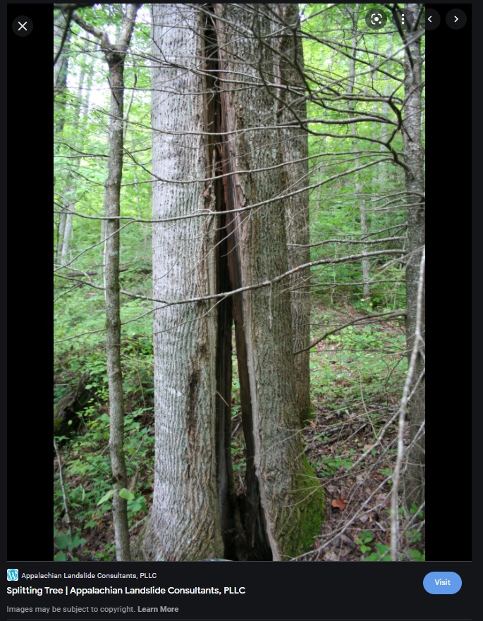
The elongated crack Clingman described split a large poplar tree, leaving one half remaining standing. Trees can certainly be split by landslide movement, as indicated by the image below. Note that this image is on an extensional headscarp. Presumably, a similar effect could develop along a lateral scarp, particularly in the presence of extremely large trees, which are often absent from modern Haywood County’s slopes after more than a century of timber harvesting.
Despite largely translational motion, the slide appears to be thick enough to have experienced back-rotation of blocks near its head. Rotated blocks would nicely fit the description of the “hillocks” with tilted saplings that were well established prior to the tilting.
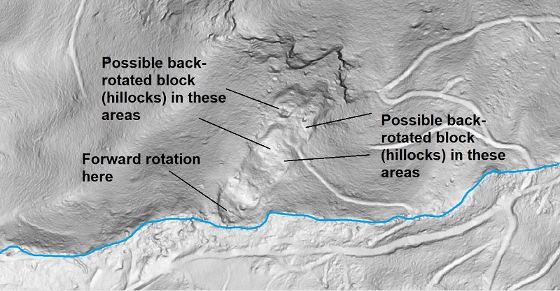
Block rotation would also create depressions on the hillside, which Clingman referenced on one of his later visits to the site. The conceptual cross section drawing below illustrates a generally translational slide whose main failure surface is roughly slope parallel, but is much steeper at its uppermost breakaway point due to the thickness of the slide. As portions of the slide mass that started above the steep failure surface move onto its less steep portions, they back-rotate and tilt the original ground surface to a flatter slope, often sufficiently to create surface depressions.
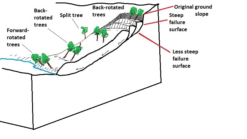
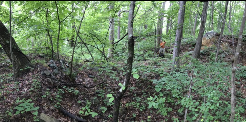
The image below, from the same Rutherford County slide that hosts the lateral crack, shows a large depression with adjacent rotated blocks, whose movement has caused tilting of a large tree at left. These landforms are typical of hummocky topography observed in the upper extensional zones of large slides. Perhaps Clingman saw a scene like this at Split Mountain?
Compressional toe features on blocks within a slide, or at its downslope toe, can also systematically tilt trees as shown in the image below. This photo was taken at the downslope, compressional end (toe) of the Rutherford County slide.
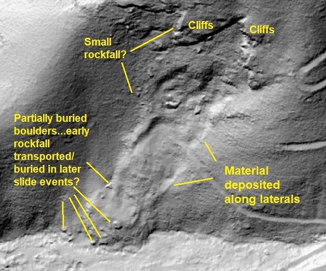
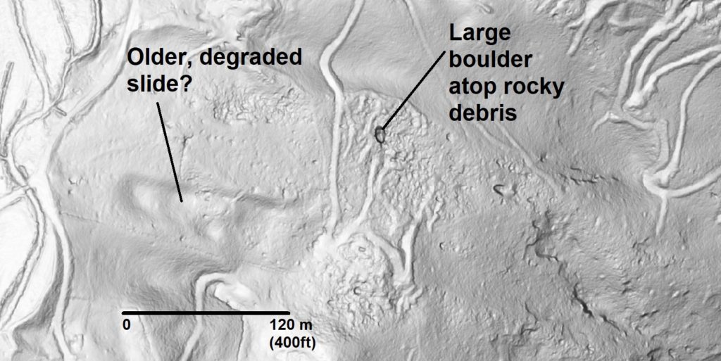
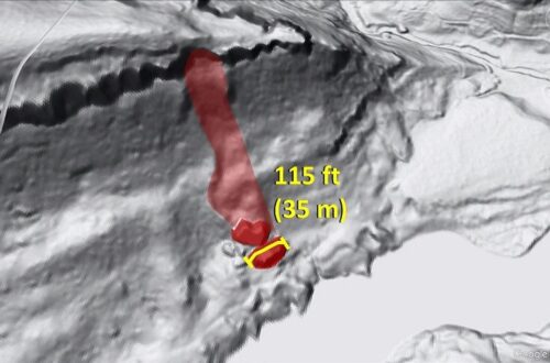
A large boulder seems to be present near the head of the Split Mountain slide, consistent with one of the features which most impressed Clingman. The source of the boulder is unclear, but its location near the head of the slide puts it in a good location to have interacted with “chasms two or three feet in width,” which were probably tension cracks in the upper, extensional portion of the slide.
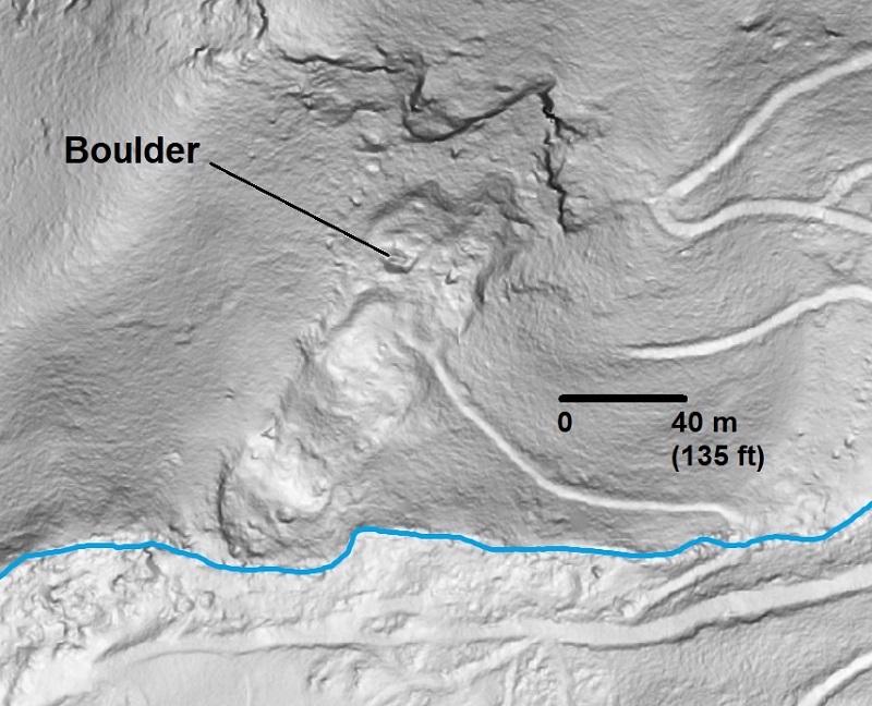
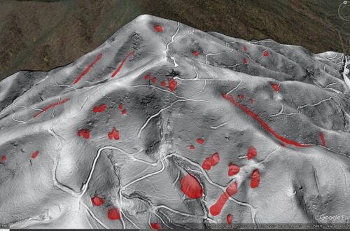
Clingman described the slide area as having prolonged activity, with rockfall occurring episodically for years before the larger events. Cliffs above the slide are strongly fracture- or joint-influenced, and are certainly a good potential boulder source. I think the shape of the outcrops of the slope suggests a dip slope geometry, which would further favor rockfall (and could explain the slide itself). Early rockfall deposits may have been subsequently transported by later sliding or buried by later addition of material; Clingman references the continually changing appearance of the slide, indicating ongoing activity. The hillshade image below shows some of the boulder locations with a bit more detail than the slope-shade imagery.
The north side of Split Mountain also hosts extensive boulder deposits that are easily visible in lidar-derived imagery. Estimating the relative age of the deposits with respect to the slide on the south side of the mountain is impossible, but the extent of the deposits and the appearance of their source outcrops at the ridge crest, rockfall has been active for some time. Very large boulders are occasionally involved, as evidenced by the example below.
Perhaps the most interesting question relating to Split Mountain is whether the “shocks” referenced by Clingman and local residents describe the slide events themselves, which appear to have been surprisingly rapid for a somewhat intact slide, or small earthquakes that led to the slide events. The excerpted text I have read is not clear, but it at least suggests that earthquakes large enough to be felt by residents in the area might have preceded or actually caused the slides. Kathy Ross’ article references other accounts of tremors and “cracked mountains” southwest of Split Mountain, but these, too, may have been mistranslated over the years. Split Mountain also invites comparison to the 1874 events at Rumbling Bald in Rutherford County, where seismic events followed by or associated with slope movements appear to have occurred.
From my own perspective, I am interested by the lidar appearance of the Split Mountain slide with respect to its age, assuming it is the right one. Estimating landslide age in the field and remotely via lidar is tough, and is ultimately a somewhat subjective judgment call. A field visit to this slide would be very useful, particularly in terms of seeing how scarps and cracks degrade over a known time interval (check out the last image).
Clingman’s observations also highlight the importance of qualitative understanding of mass movement and its consequences. He probably never watched any sort of landslide happen (or slowly develop), which is certainly a hit-or-miss game in Appalachia today. Even if he had interacted with some sort of large slide event, it would have been almost impossible to have a vantage point to watch the movement and its effects on the slide mass. He also had no way to view the slide from above or without considerable obstruction by trees and vegetation (enter: lidar). As a result, he attributed the surface features he saw to a force pushing up from below, possibly in the way soil expands and cracks when lifted upward by a shovel. He ultimately settled on the expansion of subterranean gases as the cause of the Split Mountain events. Indeed, vertical offset along extensional scarps could give the impression of “upheaval” instead of rotation or relative subsidence, as evidenced by the photo below from the Rutherford County reference landslide.
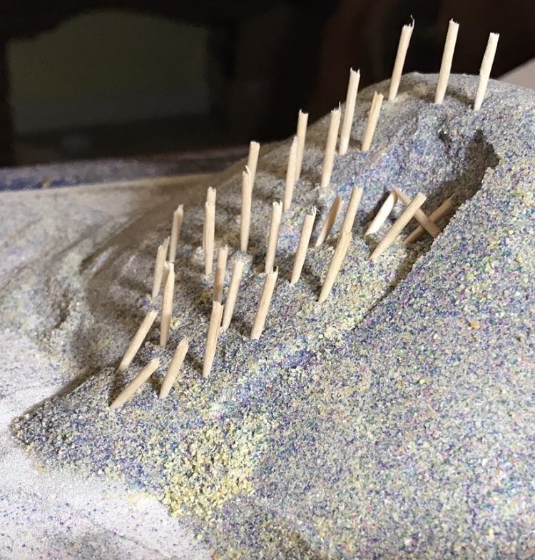
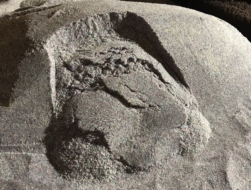
Today, the perspective provided by lidar-derived imagery, an endless supply of YouTube videos, and other approaches such as physical modeling allow geologists to become familiar with the sometimes surprising types of landforms that develop due to slope movement. The small physical models shown below illustrate ground slope tilting and the complex fracture patterns that can develop in the extensional portions of largely intact landslide masses.
In the Appalachians, this basic understanding of landslide-derived landforms is particularly important, as heavy vegetative cover makes interpretation of landslide-associated topography even more difficult. Clingman’s account clearly shows he faced the vegetation challenge on his visit to Split Mountain, but he was able to use tree deformation to his advantage in describing the details of ground movement he observed. While he may have missed the mark on his interpretation of the features, his attention to detail in recording the relevant features of the landscape was right on target, and his account was immediately understandable to a geologist in 2021, over 150 years after he wrote it!

You May Also Like
Lidar imagery reveals details of debris flow movement in the eastern Blue Ridge Mountains of North Carolina
Another track left by huge boulders visible with lidar, Big South Fork National River, Kentucky
One Comment
Pingback: