Where Did That Boulder Come From? A LiDAR Perspective On A Large Appalachian Rockfall
by Philip S. Prince, Virginia Tech Active Tectonics and Geomorphology Lab
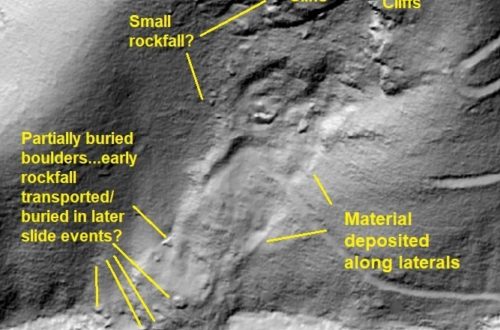
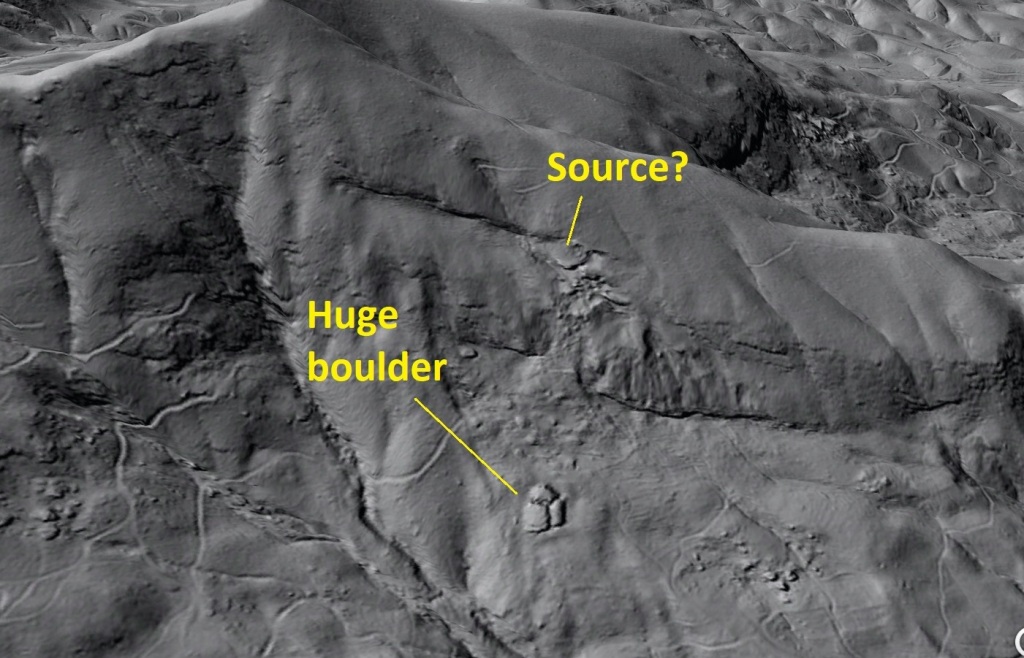
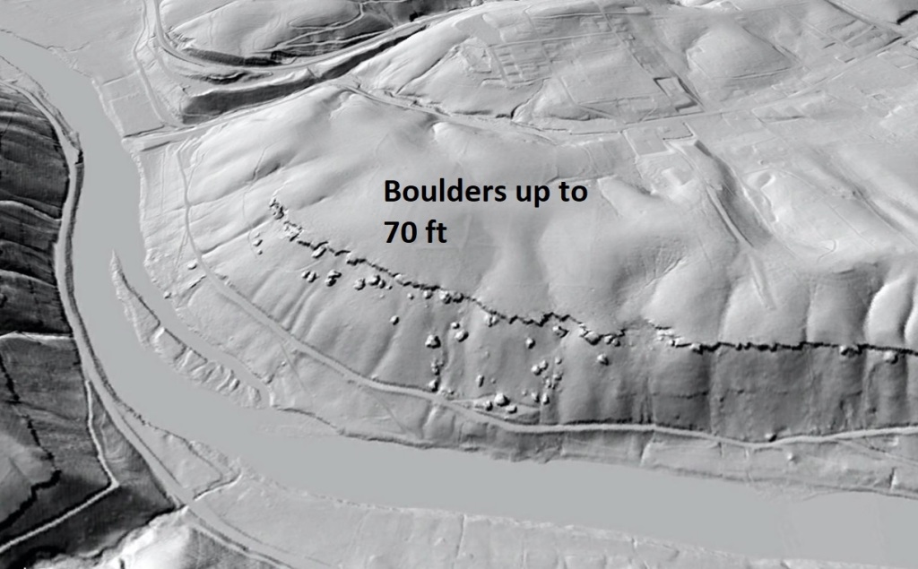
Large boulders are a common feature on hillslopes throughout the rugged portions of southern Appalachia. “Large” is a relative term, but boulders consisting of over 10,000 cubic feet of rock (a boulder 50 ft x 30 ft x 10 ft = 15,000 cubic feet, for example) can be found in association with a wide range of rock types, river systems, and their associated landscapes. I have always wondered about the possibility of finding the specific outcrop source of large boulders, which is very difficult in the field due to vegetation and continued evolution of the cliff line after a boulder falls off and makes its way downhill. Using LiDAR-derived hillshade imagery of a portion of the Blue Ridge Escarpment in western North Carolina, I recently came across a particularly large boulder that appears to be traceable to a scar on cliffs hundreds of feet further up the slope.

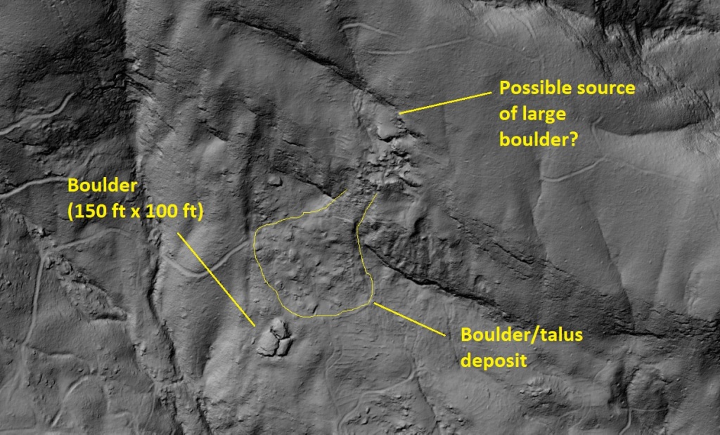
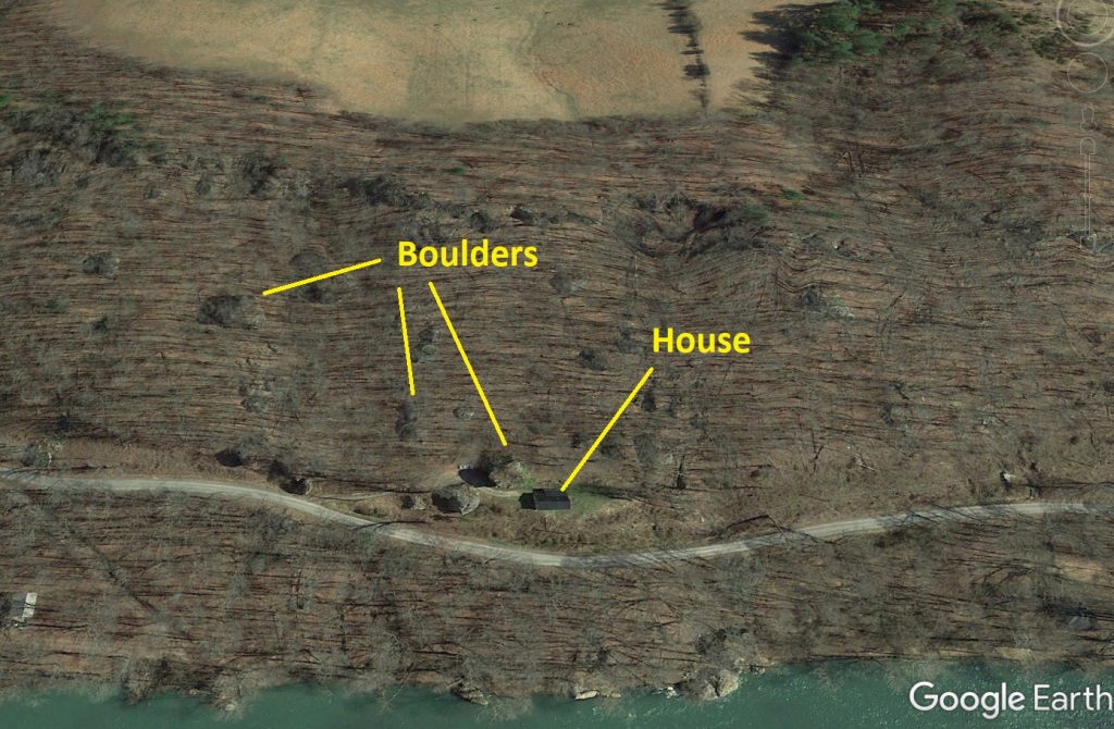
This is one big boulder. It is ~150 ft long and ~100 ft wide, and has cracked into three pieces. I don’t know how thick it is, but its survival during its trip downhill and trends in area geology would suggest it may be 20 ft thick or more. Assuming it is 20 ft thick and comparable to granite in composition (it is gneiss), it would weigh 50 million pounds (23 million kilograms). This estimate is derived from calculating the rock volume (150 ft x 100 ft x 20 ft) and multiplying by the weight of 1 cubic foot of granite (168 pounds).
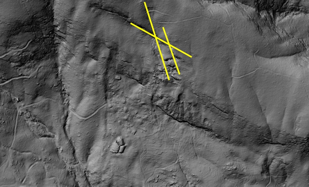
The shape of the boulder is notable, as its sides meet at angles consistent with fracture and joint intersections visible in the landscape as marked below.
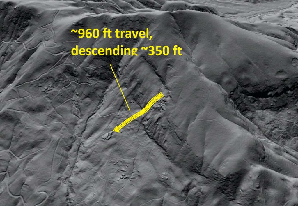
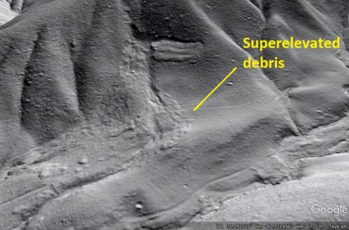
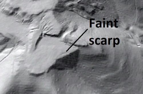
I thought this particular mega-boulder might be big enough to have left an identifiable scar where it separated from the mountainside. Looking upslope, there is indeed a potential source area that is the correct size and shape to be the boulder’s previous location. An outline drawn around the boulder fits the potential source quite well, although the cracking of the boulder has increased the size of its outline slightly. Bedrock layers visible in the image tilt downslope, setting the stage for such a large chunk of rock to slide off.
I have not visited this location in the field, so I can’t confirm that the scar is indeed the source. I think this would still be very difficult because the potential source area is not a distinctly different layer of rock from areas below it. The intersecting fractures that shape the boulder are also present throughout the landscape, so in theory many areas along the cliff line could be the source. Even so, the matching size and shape of the boulder and potential scar, along with the appearance of the slope beneath the scar, make good evidence for a positive identification of the boulder’s source.
Assuming the scar is indeed the boulder source, the boulder traveled ~960 ft (just under 300 m) over the ground surface, descending ~350 ft ( about 110 m). The boulder appears to have rotated clockwise slightly during its travel. I am always amazed that boulders like this do not completely break apart during their slide. This one did not experience freefall off of a cliff, but its path was far from a perfectly smooth plane.
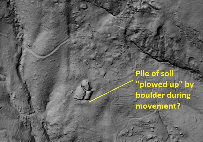
It would be interesting to dig a trench on the downhill side of the boulder to see if it disrupted the soil ahead of it during its trip down the slope. Charcoal caught up in the disrupted soil might be useful in setting limits on the age of the boulder movement, depending on how young or old it actually is. Because the feature is located on private property, this probably won’t ever happen!
The boulder is composed of gneiss, one of the tougher high-grade metamorphic rocks in this region. Pennsylvanian-aged sandstones further west in the Appalachian Plateau can produce even more impressive boulders, and all thick-bedded, quartz rich sandstones in the sedimentary Appalachians have the potential to fall apart in enormous chunks that survive downslope transport. As far as I know, there aren’t any recorded instances of these massive boulders moving, and most are just a normal part of the landscape and forest. In most cases, I don’t think its even clear if each boulder moved rapidly in one event or gradually crept down the slope.
In the case of the North Carolina example, I certainly imagine a rapid, single event that would have been very impressive to watch.
LiDAR data source: QL1 lidar data acquired by NC Dept. of Public Safety, raw point clouds assembled and processed by Corey Scheip of the NC Geological Survey Landslide Hazards Program.
You May Also Like
Lidar imagery reveals details of debris flow movement in the eastern Blue Ridge Mountains of North Carolina
Lidar hillshade imagery hints at the location of a future coal spoil landslide