The Pigeon River is Perched, Which is Geologically Bad News
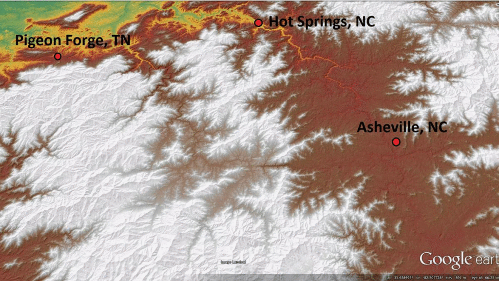
A reader of the Nantahala Gorge post asked a very relevant question: Is there a stream capture in the Appalachians that is going to happen soon? While “soon” can be a very relative term in geology, there is most definitely a good answer to the question. At Canton, North Carolina, the headwaters of Hominy Creek, a French Broad River tributary, are VERY close to capturing the Pigeon River. In human terms, this is still probably a long way off, but it is most certainly geologically “imminent.”
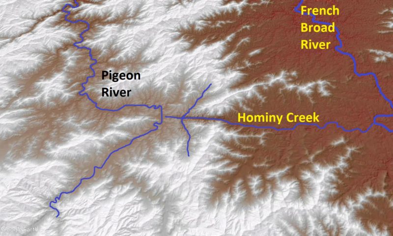
Much like the Nantahala scenario, this is a capture between neighboring river valleys that are both part of the Tennessee River system. Today, their waters meet in the Tennessee Valley within 10’s of miles of the imminent capture point. Even so, the Pigeon River valley is “perched” (yes, a real geologic term) about 400 ft (125 m) higher than the neighboring Hominy Creek/French Broad valley in the area where the capture will occur. Because these neighboring rivers have strongly contrasting elevations, the lower river system (French Broad) has the potential to capture from the higher river system (Pigeon).
This capture is, geologically speaking, “inches” away from happening. The headwaters of Hominy Creek are about 1,500 ft (450 m) ground distance from the banks of the Pigeon River at the Evergreen Packaging paper mill. There is no dividing ridge between the two streams; the actual drainage divide is only about 20 ft (6 m) higher than the Pigeon itself, and it is so subtle as to be nearly invisible in the landscape.
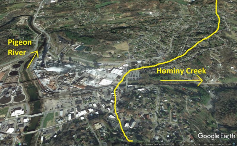
It probably would not be too difficult to construct a canal to link the Pigeon and French Broad River systems through Hominy Creek. When the future stream capture creates this link, the introduction of the Pigeon’s flow across the 400 ft descent to the French Broad River valley will produce impressive rapids and falls and carve a deep gorge. Would-be engineers of the “Canton-Asheville Canal” would have to carefully control the water over this descent with dozens of locks and dams. Fortunately, Interstate 40 provides a much better means of traveling between the two river systems.
The headwaters of Hominy Creek show that it has been advancing into the Pigeon River system through the recent geologic past. Many stream networks develop “accordant junctions” between tributaries and the main stream, meaning that the angle between the tributary and main stream is well below 90 degrees on the upstream side of the junction. In other words, the layout of a stream system looks like a tree with branches, with the flow direction of the stream being from the tips of the branches towards the base of the trunk.
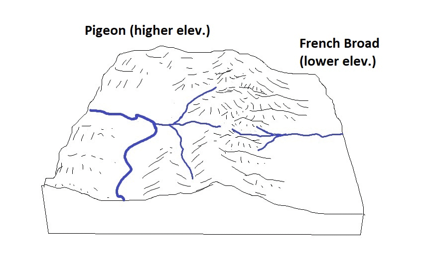
Upper Hominy Creek shows the opposite pattern. Two of its tributaries are angled as if they still flow to the Pigeon, but Hominy Creek now flows the opposite direction. These tributaries did indeed flow to a stream that once continued to the Pigeon. Hominy Creek’s “ancestor” ate its way into the elevated Pigeon Valley, carving right up the existing stream channel and progressively inverting it to flow towards the French Broad.
The inversion process is possible because Hominy Creek and the now-inverted Pigeon tributary flow down a very weak zone in the bedrock that is easily eroded. This weak zone is probably a fault or area of very intense fracturing of the rock, which makes it more susceptible to erosion and thus a good place for stream courses to localize.

Like many Appalachian stream captures, it is difficult to attribute this scenario to a specific geologic cause. Because the Pigeon and French Broad flow parallel to each other, are part of the same river system, and actually meet each other not too far from the future capture point, it is unlikely that they have experienced very different histories in terms of climate/precipitation or uplift of the land surface. What can be said for sure is that the French Broad is much larger, making it more capable of carving its valley down to match Tennessee Valley elevation, and it flows across notably different geology as it leaves the Blue Ridge.
The different rocks crossed by these rivers may indeed play a role in setting the stage for capture, just like in the Nantahala scenario. If the smaller Pigeon River also crosses harder rock in its lower reaches, it will be unable to keep pace with downcutting in the Tennessee Valley. The larger French Broad River, by contrast, has more water volume to attack less resistant rock, allowing it to keep pace with the Tennessee Valley. This scenario leaves the Pigeon stranded above the French Broad and susceptible to the capture that is going to occur.
No one can really say much about when this capture might occur, but it’s not time to sell property or charge up your camera to film it. While rates of landscape evolution in the Appalachians are intensely studied and hotly debated, it is safe to put this event in the “geologic” near future, which in human terms might still be a really long way off. Even so, this capture is extremely close to occurring, and I would not be surprised to know that land draining to the Pigeon on its surface loses groundwater into upper Hominy Creek today.
Additionally, it is interesting to consider the effects of something like a large recurrence interval flood on the Pigeon-Hominy Creek system. Were the Pigeon to rise massively out of its banks, perhaps by several feet, its waters would be lapping much closer to its divide with Hominy Creek, which rises only 20 ft (6 m) above the modern river level. To my knowledge, no recorded flood has produced this result, but it is not an unreasonable way to think about how the very first moments of the actual capture process could start. In Virginia’s Shenandoah Valley, a flood actually caused the North River to spill out of its banks and drain into neighboring Mossy Creek. I suppose this could be considered the beginning of the actual capture sequence between these two streams, which are small and whose confluence is close to the spillover point (a geologist wrote about this decades ago; his name escapes me). In the Pigeon’s case, I don’t think a spillover-causing flood is even remotely conceivable, but with a bit more advance by Hominy Creek and perhaps eastward migration of the Pigeon channel, repeated flood circumstances of this type might get the capture ball rolling in the geo-future.
