-
An Abandoned River Valley and the “True Depth” of Appalachia’s Deepest River Gorge
by Philip S. Prince, Virginia Tech Active Tectonics and Geomorphology Lab
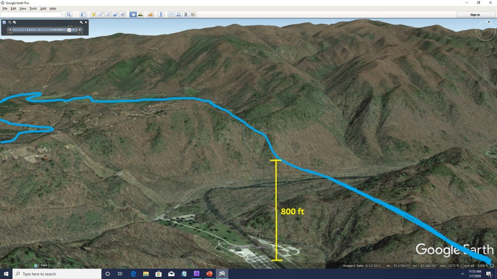
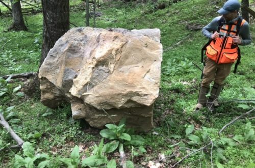
In the last “Deepest Gorge” post, I said the depth of the North Carolina’s Nantahala Gorge could be measured as either 3200 ft (975 m) or 800 ft (243 m). The big difference between these numbers results from distinguishing between background topography and a specific gorge-forming event within that topography. I like the 800 ft figure because it speaks to a measurable episode of gorge deepening that can be tied to a specific geologic cause. The Nantahala Gorge is actually one of the best places on the east coast to see how a geologist can use landforms to pick out and measure a gorge-deepening episode (the 800 ft) within an already rugged, high relief “background” landscape (the additional 2400 ft). This post centers around an oddly meandering, dry valley 800 ft above the northwest wall of the gorge (outlined in yellow below). It’s not much to look at in Google Earth imagery alone, but with enhanced maps and some understanding of how river gorges spread through topography, it gives great context for different ways of thinking about gorge development.
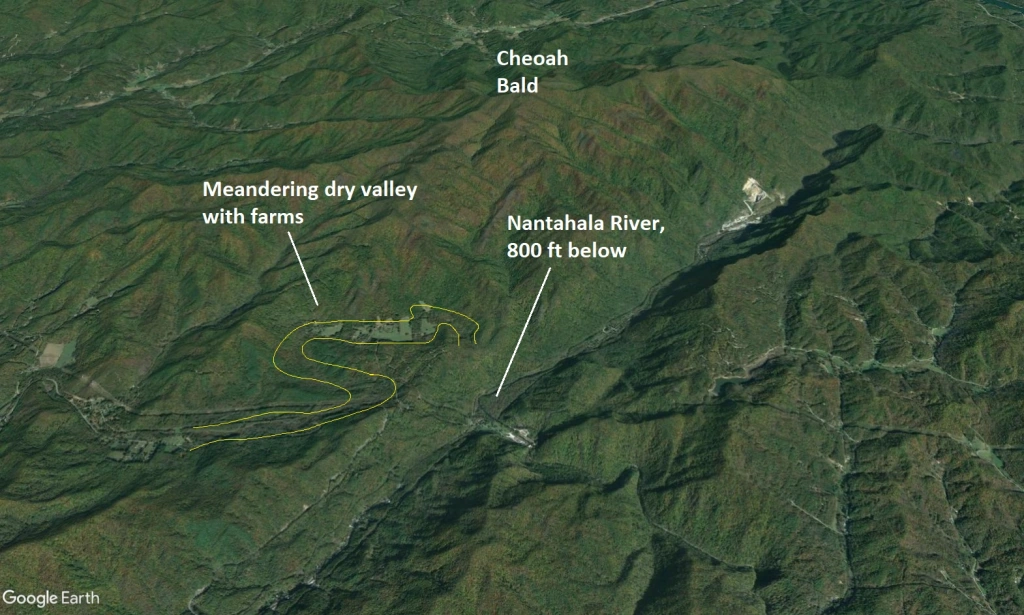
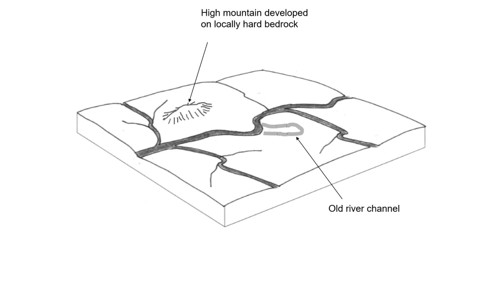
I kept the yellow lines faint to try to show how hard it is to see the meandering dry valley from land surface photography alone. Compare it to the colored digital elevation models below later in the post. As a geologist, I associate gorges with a scenario in which river downcutting has become notably faster than the evolution of the surrounding landscape. This results in rapids and falls efficiently carving narrow, steep-sided gorges in rivers and their largest tributaries while the rest of the landscape waits for the downcutting to spread through smaller tributary streams. An interesting consequence of this lag between river and large-scale landscape response is the survival of old topographic features that end up temporarily “perched” above the newly carved gorges before they are consumed by the spreading wave of erosion. The old river channel in the GIF below is an example.

Let this one run for a while and watch the steep gorges spread through the stream network. In a real landscape evolving in this fashion, zones of rapids or falls would typically mark the upstream limit of the progress of river downcutting, which is slower in smaller streams. As a result, parts of the pre-gorge landscape can last for a good while as they wait for erosion and steepening to make its way through the smallest parts of the drainage network. The old abandoned river channel is clearly of river origin (perhaps the meandering valley in the first photo also has a river-like shape?), and is a nice marker for the general elevation of the river system before it began carving into the landscape more quickly. As the active river carves its gorge, the old channel ends up stranded higher and higher above the active river as the gorge grows deeper. As the steep walls of the gorge begin to spread outward into the landscape, they gradually chew away at the old channel, but parts of it continue to survive as a reminder of the pre-gorge river elevation. Geologists look for features like the old channel (they ain’t always this obvious) to understand the history of river downcutting throughout entire drainage networks as shown below.
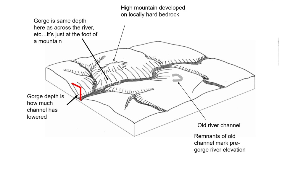
Gorge depth at the foot of the high mountain looks huge, but examining all parts of the landscape shows that only a modest part of the apparent depth relates to river downcutting. The rest is pre-existing topography on the hard bedrock. Looking at the old channel, rapids in the streams, and tributary channels upstream of gorges allows reconstruction of the pre-gorge landscape (top image). Next question: why did the downcutting occur? While the little scrap of old river channel is an unimpressive landscape feature, it is very useful in improving specific understanding of how the river system is shaping the landscape. By comparing its elevation to the upstream limits of gorges in river tributaries, it is possible to reconstruct the pre-gorge landscape (top image) and keep the apparently huge gorge depth at the foot of the high mountain in context. This shockingly deep portion of the gorge can be identified for what it really is–a modestly deep gorge carved into a pre-existing area of unusually high and steep topography developed on hard bedrock (like Cheoah Bald above the Nantahala).
So, if you can just find some sort of pre-downcutting marker in the landscape surrounding a real gorge system, you can 1) see a specific amount of river downcutting within the “noise” of pre-existing topography, 2) possibly connect downcutting to a geologic cause, 3) enhance understanding of the landscape and how to best interact with it, and 4) show that geomorphology studies are worthwhile, etc. etc. Because all parts of the Appalachian landscape are constantly changing (even if more slowly than river valleys), finding identifiable old topographic markers above gorge systems is tough and often impossible. It gets easier with colored digital elevation models that show only landforms and elevation without the distraction of actual land cover (like the GIF below). Old, subtle landforms often become visible in these maps, and the meandering dry valley 800 ft above the Nantahala is a good example.
For the geologist, seeing landforms with color-coded elevation is hard to beat. The Nantahala River is marked in blue in the image below; it flows from the white high elevation areas at the bottom of the image towards the top. The river enters the deepest part of the Nantahala Gorge where it makes its abrupt, 90-degree turn to the northeast; the Nantahala Cascades are just down and right (upstream) of the 90-degree turn. The meandering dry valley is immediately up and left of the 90-degree turn. If you train your eye, you may be able to pick it out (it’s gray to light brown).
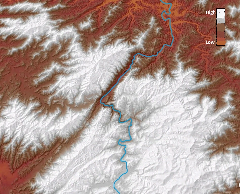
Visualize the blue line going straight then turning left instead of making the hard right turn, and you will likely see the faint dry valley. This is where it gets good. If you look at the image above or the zoomed image below, you might be able to imagine the river not making the 90-degree turn and just continuing right on through the meandering valley. This is indeed what used to happen, but the meandering dry valley is now 800 ft above the modern Nantahala. It is still very recognizable as a river valley, albeit a mostly dry one, and its elevation fits well with the upper end of a zone of rapids that has migrated up the Nantahala (the Cascades) from the 90 degree bend. Just like the cartoon model a few images back, this “perched” remnant river valley is a nice marker of the where the river used to be before it carved the last 800 ft of gorge in association with the major change in its course. Because the remnant valley has not been eroded away or completely buried in sediment, it is safe to say that the last 800 ft of Nantahala Gorge development have happened quickly compared to the rate at which much of the surrounding landscape is changing.
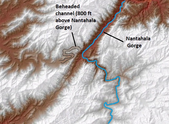
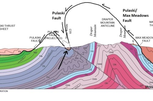
The meandering dry valley is labeled “beheaded channel” here (see below). I outlined it in black to make it more visible. Its shape, slope, and elevation make it very clear that it is the former course of the pre-gorge Nantahala. So what does the 90 degree turn have to do with gorge development, and why do I call the meandering valley a “beheaded channel?” Like many Appalachian rivers with gorges, the Nantahala is a victim of stream capture. If neighboring river systems have very different elevations, the outer tributaries of the lower system tend to erode their way into the higher system. This leads to natural diversion, or capture, of the elevated rivers into the lower valley network. The Nantahala and its tributaries are hundreds of feet higher than the neighboring Little Tennessee system, setting them up to be capture victims. As crudely illustrated below, a little Tennessee tributary ate its way through soft rocks in the Murphy Syncline and intersected the old Nantahala, capturing it. This produced the 90 degree bend, caused the 800 ft of downcutting as the Nantahala carved down to match Little Tennesee elevation, and “turned off the water” to the valley below the capture point. Because the now (mostly) dry stream valley no longer has headwaters to supply it, it is described as “beheaded.”
The lower elevation Little Tennessee attacks its high elevation neighbor, the Nantahala. The Nantahala capture occurred where the a Little Tennessee tributary ate its way through weak rock to reach the Nantahala. This brought the gorge to its present depth, and sent a wave of downcutting through the Nantahala system that is presently seen at the Nantahala Cascades. Note that Cheoah Bald was a big mountain before the capture occurred; the subsequent gorge development just increased its relief above the modern Nantahala. The whole point of using the Nantahala example is to show the value of taking a closer look at the overall geologic context of landscape superlatives (highest, deepest, etc.). While only 800 ft of the 3200 ft of gorge topography relates to the geologically recent downcutting, these 800 ft occurred at a rate faster than the evolution of the surrounding landscape, and can be viewed as “undercutting” the already steep mountain topography and its 2000+ ft of topographic relief. This undercutting has set the stage for regular landsliding, which is an expression of the landscape around the gorge trying to catch up to the Nantahala and better match its new elevation and course to the Little Tennessee. Many of the “deepest gorge” candidates from the previous blog also experience regular landsliding for the same reason–they represent recently excavated topography that is in a phase of adjustment to a newly lowered river elevation. The majority of the “deepest” candidates are also clearly stream capture-related, meaning their development is river system-specific and may not necessarily reflect what is going on throughout the entire Appalachian range.
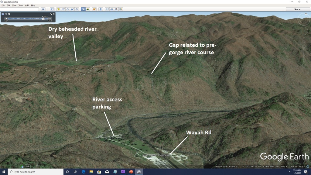
I’m not sure if the gap is visible from ground level or not. Although it erosion has lowered it somewhat, it’s a good reference for the pre-gorge elevation of the old Nantahala. I have not spent much time around the Nantahala, but I think it would be possible to see some evidence of the pre-gorge river elevation from river level. Standing near the Wayah Road bridge over the river and looking downstream (see above), a gap in the north wall of the gorge might be visible from the road or adjacent fields. This gap is where the pre-gorge, pre-capture river flowed, although the gap has been lowered somewhat by erosion spreading outward from the gorge. If you were looking up at this gap, you would have to visualize the old Nantahala flowing 800 ft above you, atop bedrock which has been carved out by erosion and transported downstream!
How some geologists see landscapes… While the colored DEM is the best way to see the old Nantahala course preserved at the lip of the gorge, it is somewhat visible in Google Maps using the Terrain function (go to 35.282750N 83.690604W). I have faintly outlined the valley in the image below.
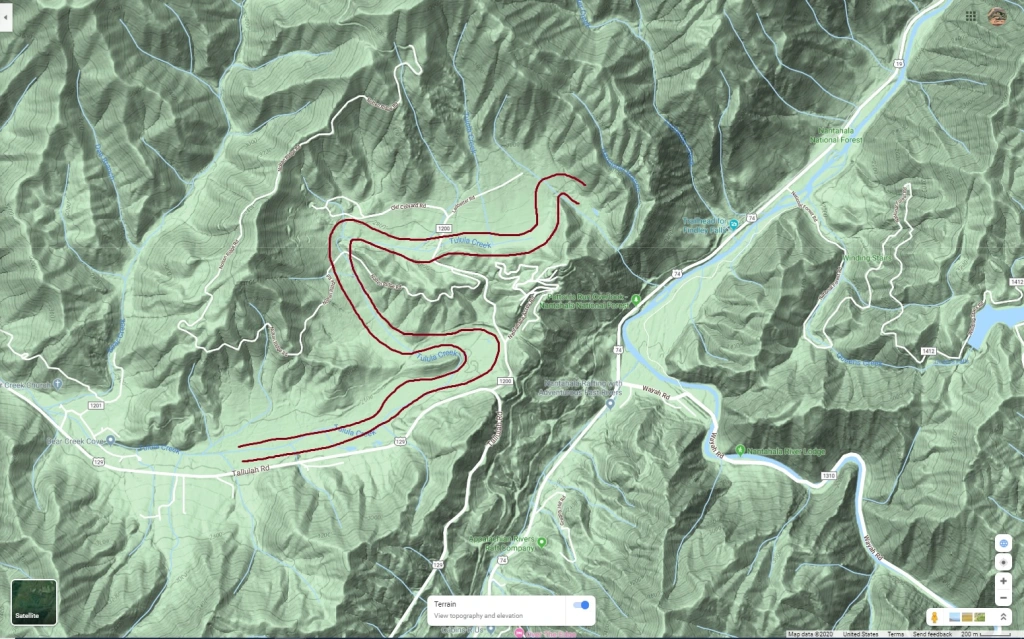
Google Maps Terrian makes the dry valley somewhat visible, but elevation color coding (like in the DEM) really helps things. While the valley is surprisingly well-preserved, it is being attacked by erosion from the Nantahala Gorge. The tiny stream draining its east end to the Nantahala drops over an impressive waterfall as it descends the 800 ft to the river. The remainder of the valley that still drains to the west has been filled in to some extent by sediment being shed from the steep hillslopes above it. The low slope of the valley is consistent with a good-sized river (the old Nantahala) flowing through it; the river would have had enough water to efficiently move the sediment supplied to it. Now that capture has turned the water off, the sediment just piles up because the tiny creek in the valley certainly can’t transport it with its low flow and low gradient. Even in its beheaded state, the valley goes to show that no spot in the landscape is completely protected from change over time.
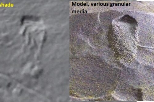
Interestingly, geology seek to identify “pre-gorge” landscapes in settings around the world to try to determine how much rivers have carved into the landscape and why. A particularly cool application of the technique is its use to try to connect focused uplift in mountain ranges with moving faults miles deep in the earth and associated earthquake hazard. This paper is a good example, and this post tries to illustrate the concept with a sand model.
-
The Pigeon River is Perched, Which is Geologically Bad News
A reader of the Nantahala Gorge post asked a very relevant question: Is there a stream capture in the Appalachians that is going to happen soon? While “soon” can be a very relative term in geology, there is most definitely a good answer to the question. At Canton, North Carolina, the headwaters of Hominy Creek, a French Broad River tributary, are VERY close to capturing the Pigeon River. In human terms, this is still probably a long way off, but it is most certainly geologically “imminent.”
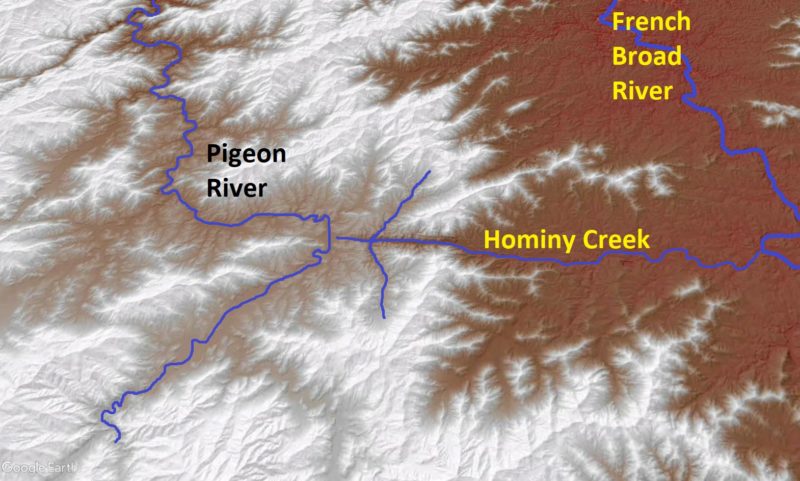
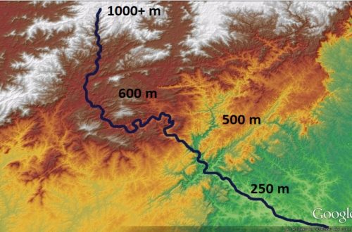
The future capture will occur where the headwaters of Hominy Creek, which flows to the French Broad River, appear to nearly touch the Pigeon River just left of center. This color-coded elevation map does a nice job of showing the elevation contrast between the two neighboring river systems, which sets the stage for stream capture. The map area is about 25 miles (40 km) across. Canton, North Carolina is located where Hominy Creek and Pigeon appear to nearly touch on this map. Note the weird umbrella/anchor/grappling hook/whatever shape of the Hominy Creek headwaters…this is discussed further down. Much like the Nantahala scenario, this is a capture between neighboring river valleys that are both part of the Tennessee River system. Today, their waters meet in the Tennessee Valley within 10’s of miles of the imminent capture point. Even so, the Pigeon River valley is “perched” (yes, a real geologic term) about 400 ft (125 m) higher than the neighboring Hominy Creek/French Broad valley in the area where the capture will occur. Because these neighboring rivers have strongly contrasting elevations, the lower river system (French Broad) has the potential to capture from the higher river system (Pigeon).
This capture is, geologically speaking, “inches” away from happening. The headwaters of Hominy Creek are about 1,500 ft (450 m) ground distance from the banks of the Pigeon River at the Evergreen Packaging paper mill. There is no dividing ridge between the two streams; the actual drainage divide is only about 20 ft (6 m) higher than the Pigeon itself, and it is so subtle as to be nearly invisible in the landscape.
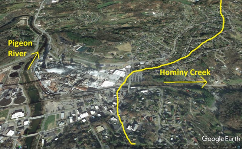
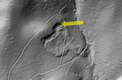
Paper mill buildings are visible at the center of the image. The yellow line is the drainage divide between Hominy Creek and the Pigeon. I have not actually been to this spot, but I would be curious to see how discernible the features are due to development. Right now, the point where the railroad tops out and enters the mill is the leading edge of Hominy Creek’s attack. It probably would not be too difficult to construct a canal to link the Pigeon and French Broad River systems through Hominy Creek. When the future stream capture creates this link, the introduction of the Pigeon’s flow across the 400 ft descent to the French Broad River valley will produce impressive rapids and falls and carve a deep gorge. Would-be engineers of the “Canton-Asheville Canal” would have to carefully control the water over this descent with dozens of locks and dams. Fortunately, Interstate 40 provides a much better means of traveling between the two river systems.
The headwaters of Hominy Creek show that it has been advancing into the Pigeon River system through the recent geologic past. Many stream networks develop “accordant junctions” between tributaries and the main stream, meaning that the angle between the tributary and main stream is well below 90 degrees on the upstream side of the junction. In other words, the layout of a stream system looks like a tree with branches, with the flow direction of the stream being from the tips of the branches towards the base of the trunk.
In the first panel, where the river systems are labeled, the “normal” branching patterns and flow directions are represented. As Hominy Creek eats its way into the Pigeon system, it inverts and reverses the normally branched stream network to make the odd drainage pattern. Peter Vogt called this pattern a “grapnel” shape in a paper in the 90s, and I used that term in my own subsequent work. Upper Hominy Creek shows the opposite pattern. Two of its tributaries are angled as if they still flow to the Pigeon, but Hominy Creek now flows the opposite direction. These tributaries did indeed flow to a stream that once continued to the Pigeon. Hominy Creek’s “ancestor” ate its way into the elevated Pigeon Valley, carving right up the existing stream channel and progressively inverting it to flow towards the French Broad.
The inversion process is possible because Hominy Creek and the now-inverted Pigeon tributary flow down a very weak zone in the bedrock that is easily eroded. This weak zone is probably a fault or area of very intense fracturing of the rock, which makes it more susceptible to erosion and thus a good place for stream courses to localize.

The dark brown gash at center is the Hominy Creek gorge. It is oddly straight because it follows a planar weak zone in the bedrock. Interstate 40 follows Hominy Creek up to Canton, taking advantage of the slopes along this straight gorge. Like many Appalachian stream captures, it is difficult to attribute this scenario to a specific geologic cause. Because the Pigeon and French Broad flow parallel to each other, are part of the same river system, and actually meet each other not too far from the future capture point, it is unlikely that they have experienced very different histories in terms of climate/precipitation or uplift of the land surface. What can be said for sure is that the French Broad is much larger, making it more capable of carving its valley down to match Tennessee Valley elevation, and it flows across notably different geology as it leaves the Blue Ridge.
The large-scale context of the future Pigeon capture is interesting. At the top of the image, you can see where the rivers are about to meet in the sedimentary rocks of the Tennessee Valley. This map area is about 55 miles (90 km) across. At this zoom, the higher elevation of the Pigeon system (the white area) is very apparent. The geology of this area is extremely complex, but the Pigeon crosses different rocks (greens) from the French Broad (yellows) as they exit the Blue Ridge near the top of the image. Geologic map by Thigpen and Hatcher (2009); citation linked here as I can’t find a live link to the full document. The different rocks crossed by these rivers may indeed play a role in setting the stage for capture, just like in the Nantahala scenario. If the smaller Pigeon River also crosses harder rock in its lower reaches, it will be unable to keep pace with downcutting in the Tennessee Valley. The larger French Broad River, by contrast, has more water volume to attack less resistant rock, allowing it to keep pace with the Tennessee Valley. This scenario leaves the Pigeon stranded above the French Broad and susceptible to the capture that is going to occur.
No one can really say much about when this capture might occur, but it’s not time to sell property or charge up your camera to film it. While rates of landscape evolution in the Appalachians are intensely studied and hotly debated, it is safe to put this event in the “geologic” near future, which in human terms might still be a really long way off. Even so, this capture is extremely close to occurring, and I would not be surprised to know that land draining to the Pigeon on its surface loses groundwater into upper Hominy Creek today.
Additionally, it is interesting to consider the effects of something like a large recurrence interval flood on the Pigeon-Hominy Creek system. Were the Pigeon to rise massively out of its banks, perhaps by several feet, its waters would be lapping much closer to its divide with Hominy Creek, which rises only 20 ft (6 m) above the modern river level. To my knowledge, no recorded flood has produced this result, but it is not an unreasonable way to think about how the very first moments of the actual capture process could start. In Virginia’s Shenandoah Valley, a flood actually caused the North River to spill out of its banks and drain into neighboring Mossy Creek. I suppose this could be considered the beginning of the actual capture sequence between these two streams, which are small and whose confluence is close to the spillover point (a geologist wrote about this decades ago; his name escapes me). In the Pigeon’s case, I don’t think a spillover-causing flood is even remotely conceivable, but with a bit more advance by Hominy Creek and perhaps eastward migration of the Pigeon channel, repeated flood circumstances of this type might get the capture ball rolling in the geo-future.