Is this the steepest river in the Appalachian Mountains?
by Philip S. Prince
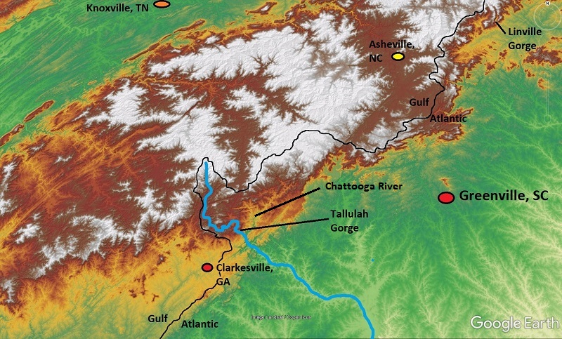
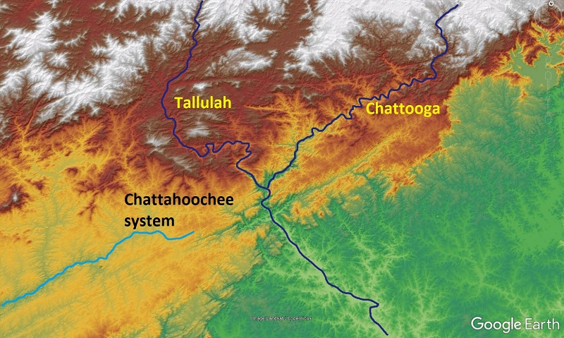
Topographic superlatives are almost always a bit arbitrary, and comparing river steepness is about as arbitrary as it gets. How long of a stretch of river needs to be considered? How big does a stream need to be in order to be considered a “river?” Since a vertical waterfall is the maximum steepness possible, is the biggest river with a freefalling waterfall the winner? How tall does the waterfall have to be? These questions all have merit, and each one can steer this search in a slightly different direction. One reach of Appalachian river, however, stands out no matter which of these parameters is applied: the gorge section of the Tallulah River of northeast Georgia.
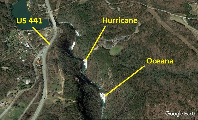
At the upper end of Tallulah Gorge, the Tallulah River drops about 400 ft (120 m) in 1 mile (1.6 km) or so (some sources say 500 ft over this distance). Much of this descent occurs across four huge waterfalls, which are easily visible in Google Earth…and which seem precariously close to US Highway 441. Oceana is the only falls directly accessible to hikers and, in April and November of each year, to whitewater paddlers. Hikers can cross a bridge over the top of Hurricane and approach its base, but the upper two falls can only be experienced from a distance due to their extreme ruggedness. Vertical rock walls are present in much of the upper gorge.
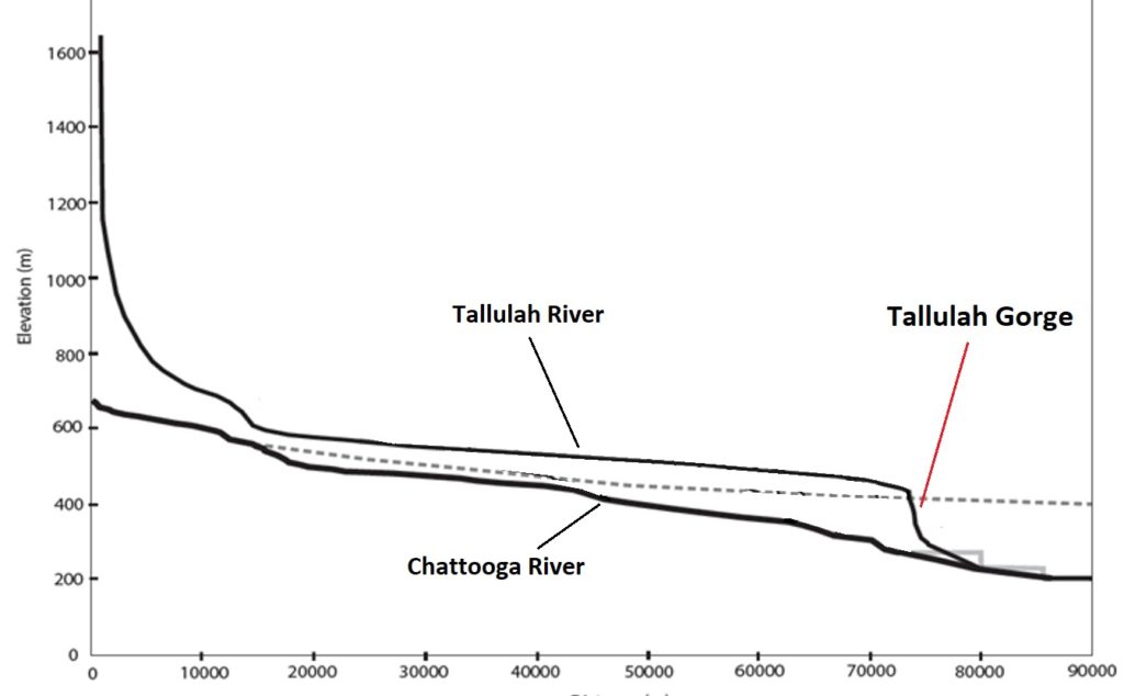
This impressive sequence of falls at the head of the gorge occurs where the Tallulah’s drainage area is ~190 square miles, or 500 square kilometers. When presented as a highly vertically exaggerated stream profile, shown below, the short but extremely steep stretch of river looks almost like a dam, and absolutely dwarfs every steep zone in the neighboring Chattooga River, a slightly larger river which the Tallulah meets just below its gorge. Not all of the Chattooga is shown here, but there isn’t anything Tallulah Gorge-like upstream of what is shown.
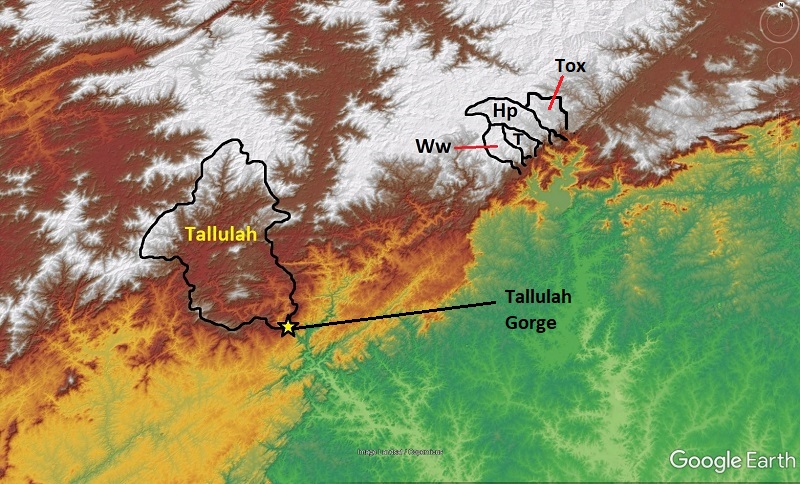
As far as I can tell, no other Appalachian river (at least in unglaciated areas) sustains a comparable gradient over 1 mile at a similar drainage area. Plenty of larger rivers have single waterfalls or sets of rapids (an example at the end of this post), but they do not approach the Tallulah’s sustained 1-mile gradient. Likewise, plenty of smaller named rivers descend more rugged topography and probably locally exceed the Tallulah’s gradient, but they are MUCH smaller rivers. The nearby Whitewater (Ww), Thompson (T), Horsepasture (Hp), and Toxaway (Tox) River basins are outlined below for comparison. Their combined drainage area would easily fit within the Tallulah basin.
The drainage area and gradient of Tallulah’s steep zone equate to impressive stream power that is not reflected in neighboring river systems. In many parts of the world, a large and atypically steep river like the Tallulah might be attributed to surface uplift due to active faults or landscape response to glacially-sculpted topography. Both of these factors are off the table in the Tallulah area. So, why is the Tallulah so big and steep? There are two reasons, and both become apparent with the aid of digital topography and geologic maps.
First and foremost, the Tallulah drainage basin has not always flowed to the Atlantic Ocean, a concept first noted by Johnson (1907). The Chattooga and Tallulah Rivers are the former headwaters of the Chattahoochee River system, which now drains the elevated plateau (yellow and brown) at lower left in the image below.
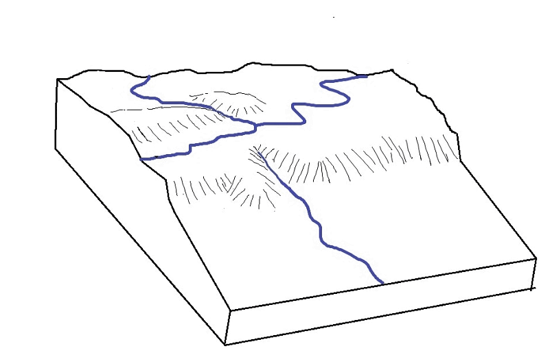
The old Chattachoochee headwaters loomed above the neighboring lower elevation stream networks of the Atlantic-draining Piedmont (green), creating a highly asymmetric drainage divide. Asymmetric divides are unstable over time, and headwaters of the Savannah system ate their way into the plateau edge, capturing the Chattooga and Tallulah and routing them off of the plateau into the lower elevation Savannah system. The GIF below animates the general idea of this process, which can otherwise be tough to visualize.
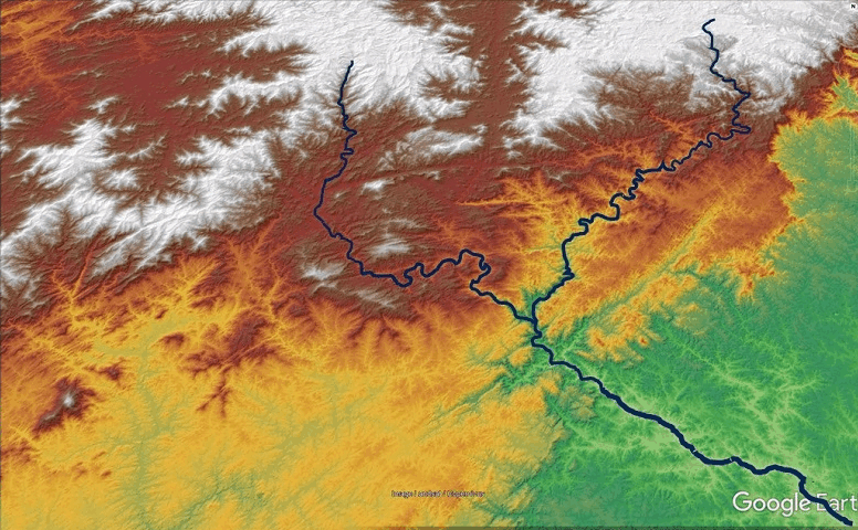
This stream capture event gave the Tallulah and Chattooga an additional ~660 ft (200 m) to descend, causing the rivers and their tributaries to begin carving deep gorges, which gradually ate their way upstream. The Chattooga (and any of its tributaries), however, don’t host any features like Tallulah’s steep stretch, which highlights Tallulah’s most significant aspect: its bedrock.
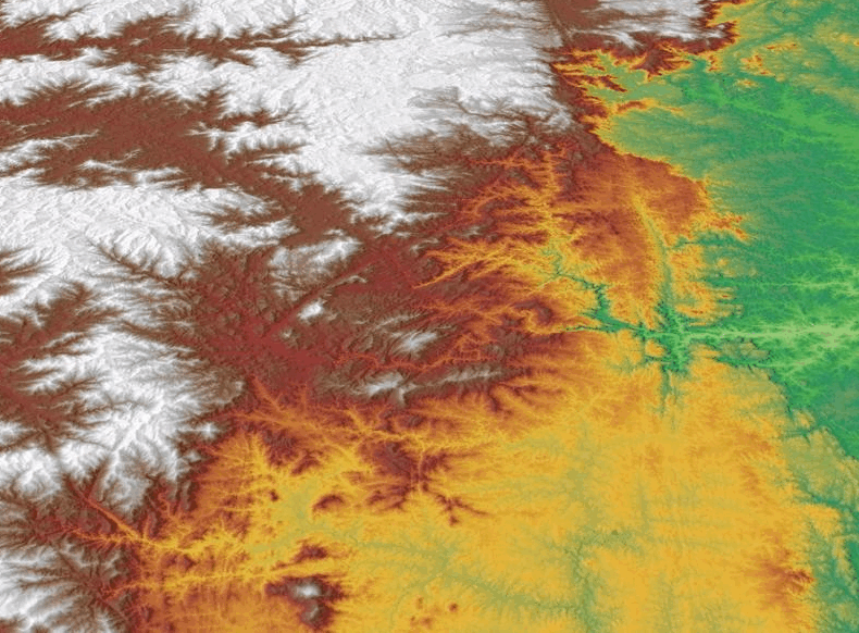
Tallulah Gorge is developed into quartzite, a metamorphic rock composed primarily of quartz (it’s not just a clever name). The quartzite, which is exposed within the Tallulah Falls Dome structure, is significantly harder/tougher/less erodible than surrounding rock types, and the Tallulah crosses plenty of it on its way to the Chattooga. In the GIF below drapes a great geologic map (Thigpen and Hatcher, 2009) over the Tallulah basin. Areas of quartzite exposure are yellow, and are widespread within the geologic dome. This map does a great job of showing the regionally atypical geology crossed by the Tallulah.
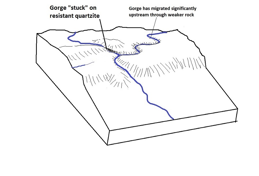
The quartzite bedrock is so resistant to stream erosion that the Tallulah has been unable to keep up with the Chattooga’s progressive downcutting in response to the stream capture. While the lower Chattooga has evolved towards a smoother transition into the rest of the Savannah system, the Tallulah has been comparatively unable to cut into its own distinct bedrock to match the Chattooga. As a result, much of the steepening related to the capture event is still “stuck” at the upper end of Tallulah Gorge, where the river is working hard to cut through the quartzite to allow the Tallulah to better match the Chattooga’s channel elevation.
This hard work takes the form of the large waterfalls, particularly the upper three falls, where the river is at its narrowest and its flow most concentrated. These falls represent the river concentrating its erosional energy as much as possible to try to catch up, erosionally speaking, to the Chattooga and the rest of the Savannah system.
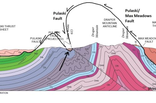
The Tallulah’s work is made even more challenging by the downstream dip, or tilt, of the quartzite layers, which is particularly noticeable at Oceana Falls. I wore a GoPro while paddling in the gorge last November to film the short video linked here. Oceana is the first rapid shown (I run it twice), and downstream-dipping quartzite horizons are clearly visible to my left. Because of this orientation, the river is less able to access weaker horizons under the quartzite, which would cause undercutting and collapse of the hard layers. The block diagram below shows one interpretation (Hatcher, 1973) of structure beneath Tallulah Gorge. The geology shown here is very large-scale when compared to the size and depth of the gorge itself, but it does give an overall sense of structure. and the position of the gorge with respect to the only slightly exposed quartzite layers. Tallulah Gorge is presently located where the yellow layer starts to tilt down towards the right side of the diagram.
The quartzite (yellow, again) is not particularly thick. It is, however, in just the right place, and is dipping just the right way, to obstruct the Tallulah’s incision and force the river to become so atypically steep, despite its size and the relatively modest elevations of the surrounding landscape.
At the end of the day, the quartzite bedrock is really what sets the Tallulah apart and controls its unique steepness. The Tallulah’s valleys upstream of the gorge are notably higher than neighboring Chattahoochee valleys, suggesting a gorge and steep stretch of river has always been present where the Tallulah steps down from the quartzite into the surrounding landscape; the capture event has simply exaggerated this step. Without the quartzite, the Tallulah landscape would look much more like the neighboring Chattooga system, which drains schist and gneiss bedrock.
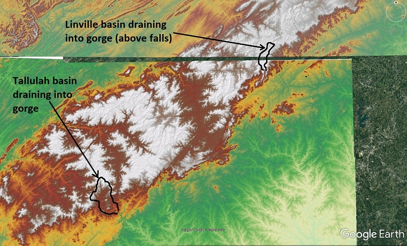
Quartzite always does interesting things in the Appalachian landscape, and the Tallulah is not the only river that interacts with this particularly tough rock type. Another noteworthy quartzite-crossing river is the Linville River, which is another stream capture victim. While the Linville descends farther than the Tallulah, it never matches the Tallulah’s one-mile maximum gradient. The Linville also drains a smaller area into the steepest portion of its gorge. Even so, the presence of quartzite within Linville Gorge absolutely impacts the length of the river’s steep stretch, presumably by slowing its downcutting and adjustment in a similar fashion to the Tallulah scenario.
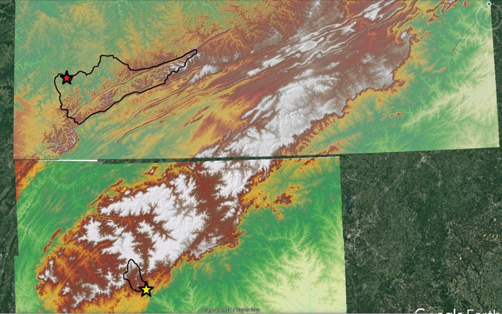
To repeat this post’s opening disclaimer, the Tallulah is noteworthy amongst rivers its size, but comparing it to significantly larger streams flowing over different bedrock is still an apples-and-oranges game to some degree. A river feature that has always impressed me is Cumberland Falls on the Cumberland River in Kentucky. This is a single, vertical waterfall is about 70 feet (22 m) high and occurs at around 2,000 square miles (5,200 square kilometers) drainage area. The image below shows the location of Cumberland Falls (red star) and the upstream drainage area, which dwarfs Tallulah (yellow star near the bottom).
Cumberland Falls is developed on sandstone overlying weaker shale, and is likely migrating upstream very quickly, geologically speaking. It is also the only feature of its type on the river, so the 1-mile scale steepness is nowhere near that of the much smaller Tallulah system. A direct comparison between Cumberland and Tallulah is complicated by completely different geologies and river system settings, but both are intriguing features that reflect geologic details of the host area.
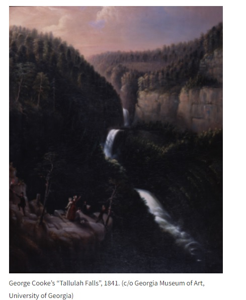
The Tallulah River and its unique character are yet to be a significant presence in scientific literature, but I expect this to change in coming years. The gorge is dramatic in person, and its connection to geologic details makes it an equally impressive example of factors that control landscape appearance on Earth’s surface. I recently ran across a great Chattooga Conservancy website that gives some Tallulah history, including the great 1841 painting shown below. The painting appears to show the upper two falls and Hurricane, which is partly obscured at lower right. The faintly tan color used for the quartzite cliffs is a good representation of their actual appearance.
According to the Chattooga Conservancy site, an author named David Hillhouse wrote in 1819 that the falls of Tallulah Gorge were surpassed only by Niagara amongst rivers he had seen. I would say that there is geologic and topographic evidence to support his opinion.